Big data is incredible! The way Big Data manages to bring sciences and business domains to new levels is almost sort of magical. It allows us to tap into a variety of avenues to access the information we normally do not access in order to gain fresh insights.
Satellite images are an amazing unconventional source to tap into for these fresh insights. Urban planners, environmentalists, and geospatial data scientists usually turn to satellite images for a big picture perspective and find insights from this exercise that brings their intended solutions to a whole new level.
Crash Course in Satellite Image Analysis a.k.a. Remote Sensing
If you ever came across the term “remote-sensing” in online articles, more likely this refers to the process of observing the earth using satellites. They’re called as such because they have the ability to make measurements remotely.
What do these remote-sensing instruments sense?The short answer is radiation. To be more technical, these instruments sense electromagnetic radiation.
These electromagnetic radiations vary in wavelength and frequencies and along this spectrum, there is a tiny portion our eyes can see known as the “visible spectrum”.
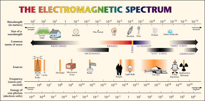
Electromagnetic Spectrum. From Bob — EDU Astronomy
This is where satellites come into play. Satellites that are orbiting the earth have lenses that can not only detect visible light but infrared wavelengths (nearest one to the visible spectrum) and microwaves.
When the light coming from the sun reaches the surface of the earth, every object reflects, absorbs, or transmits this energy differently. For example, green plants absorb all colors but reflect the green color. This is why green is the one visible to us when looking at plants. In some cases, the same type of plant may not be equally hydrated, and while this tiny difference will not be seen by the naked eye, the way these two plants reflect light will be different.
And as you know it, not all light reflected is visible.
Because surfaces reflect light differently, satellites have been used in studying vegetation, flood-prone areas and even analyzing the built-up areas of a place across the years.
While anyone can go and look up and download satellite images, they may not contain the data coming from the reflection which produces so many insights at once.
This is the data that we’re after. In the visualization that we will be doing later, the difference in color represents the difference in radiation being reflected. Since this is a multitemporal visualization (multiple time periods), the colors will represent surface of the built-up area across different time series for a place.
#data-science #philippines #python3 #analytics #geospatial