A year ago I wrote Automated Weather Model Processing With FOSS4G: Lessons Learned, which outlined my journey in creating a system that automatically retrieved, processed, and managed weather model data using open source geography software. I have now worked extensively with this system for a year, including the release of a cutting-edge weather forecasting website for the state of Colorado, and had the opportunity to learn from key players in the commercial and academic weather forecasting fields.
The findings in the original article are still useful as an introduction to common paradigms of distributing and using raw weather model data. This follow-up expands upon that and covers best practices and techniques for dealing with this data, using only free and open source software for geography (FOSS4G). There is also some tips and tricks for working with this data using JavaScript, which is becoming a more ubiquitous language, including in the field of Geographic Information Systems (GIS).
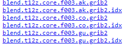
This article assumes you have GDAL installed, and you are already aware of where to download the weather model files and how they are generally structured. “Index files” will be referenced often, which are the .idx files you will often see accompanying grib2 files:
#weather-data #foss4g #javascript #weather #gis #data-science